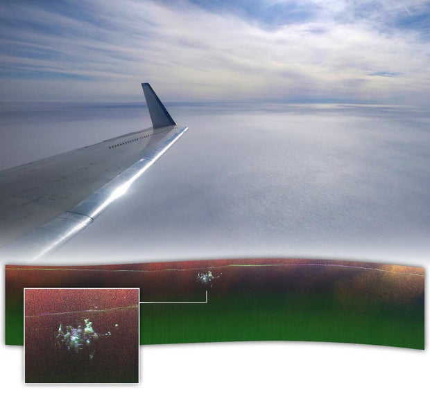
As NASA scientist Chad Greene flew over northern Greenland with a team of engineers in April, they never expected their radar to find something manmade buried deep within the ice. Greene and his team were flying above the Greenland Ice Sheet on a NASA Gulfstream III plane, scanning the barren expanse of ice that’s more than a mile deep in some areas, when their radar instrument picked up something unusual.
“We didn’t know what it was at first,” Greene said in a statement released by NASA’s Earth Observatory this week, along with new images of the discovery. “We were looking for the bed of the ice and out pops Camp Century.”
It turns out the team had stumbled upon an abandoned Cold War-era military base built by the U.S. Army Corps of Engineers in 1959. Nicknamed the “city under the ice,” the compound consists of a network of tunnels carved into the ice sheet. It was abandoned in 1967 and, over time, became buried about 100 feet below the surface as snow and ice accumulated.
The base was built as part of Project Iceworm, a then-secret plan to experiment with building a missile launch site under the Greenland Ice Sheet during the Cold War, when tension soared between the U.S. and the then-Soviet Union. Camp Century, a remote, nuclear-powered installation, was built to study the feasibility of such a project, but it was never realized and the base was decommissioned under the assumption it would be buried forever under the ice.
Pictorial Parade/Archive Photos/Getty
While the “city under the ice” had been picked up by previous radar scans, the instruments used on the NASA flight in April provided a more detailed, if unexpected, survey.
“In the new data, individual structures in the secret city are visible in a way that they’ve never been seen before,” said Greene, who works with NASA’s Jet Propulsion Laboratory.
Past scans had used a type of radar that points straight down at the ground and produces a two-dimensional scan of structures buried beneath the ice. Greene’s flight used NASA’s Uninhabited Aerial Vehicle Synthetic Aperture Radar, which is able to produce maps with “more dimensionality,” according to the agency.
A photo released by NASA on Monday showed the features of the base hidden deep under the ice, appearing as anomalies near the base of the ice sheet.
NASA Earth Observatory/Michala Garrison, Jesse Allen, Chad Greene
“Scientists have used maps acquired with conventional radar to corroborate estimates of Camp Century’s depth — part of an effort to estimate when melting and thinning of the ice sheet could re-expose the camp and any remaining biological, chemical, and radioactive waste that was buried along with it,” NASA’s Earth Observatory said in its article this week. “The scientific utility of the new UAVSAR image of Camp Century remains to be seen; for now, it remains a novel curiosity acquired by chance.”
A 2016 study of the abandoned base suggested that the facility could no longer be considered “preserved for eternity,” due to climate change increasing the rate at which Arctic ice is melting.
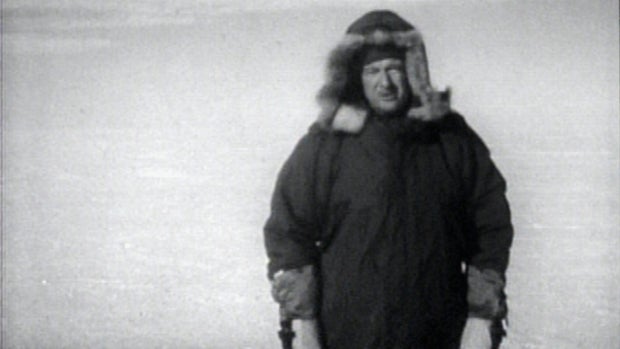
CBS News’ Walter Cronkite visited Camp Century for a tour of the still-under-construction facility for a program that aired in 1961. The camp’s commander, Captain Tom Evans, explained to him that the goals of the program were three-fold: “The first one is to test out the number of promising new concepts of polar construction. And the second one is to provide a really practical field test of this new nuclear plant. And, finally, we’re building Camp Century to provide a good base, here, in the interior of Greenland, where the scientists can carry on their R&D activities.”
CBS
The exact nature of that research and development work wasn’t discussed in Cronkite’s report for the CBS documentary show “The Twentieth Century.” (An abridged version of that report can be viewed at the link above.)
Speaking with 60 Minutes in 2016, as that show revisited Cronkite’s decades-old trip to Camp Century, producer Daniel Ruetenik said the trip was fascinating, and he marveled at the evolution of human interest in the vast, frozen expanse of the Greenland Ice Sheet.
“At the time [of Camp Century], the Cold War was considered to be the greatest threat to humanity,” Ruetenik said. “And now, the area has become a destination for climate scientists trying to study changes in the environment. So, it has a second purpose now.”


:max_bytes(150000):strip_icc()/A-Viennese-Farmer-Says-Snails-Are-the-Protein-of-the-Future-FT-BLOG0125-03-695d8dd1b8bc44d7b00811263c20d408.jpg?w=100&resize=100,75&ssl=1)

